


Güney Anadolu Sahil Şeridinin Tasviri ve Haritalanması – Phaselis’in Sonraki Toponymlerinin Kaydedilmesi Üzerine: Palyopoli-Paleopolis, Tekiroba, Gironda-Phionda-Fironda-Fionda – 1812 Yılı Hızla Yayılan Kıyı Erozyonu Raporu – Antalya Phaselis Antik Kenti’ndeki İç Liman Kolunun Üst Kısım Çöküntüsünün (Şüpheli?) Adalar ve Kanıtlar Işığında Tarihlenmesi
T. Mikail P. DUGGAN
PHASELIS III (2017) 1-48
DOI: 10.18367/pha.17001
Geliş Tarihi: 10.10.2016 | Kabul Tarihi: 27.12.2016
Elektronik Yayın Tarihi: 05.04.2017
Telif Hakkı © PHASELIS Disiplinlerarası Akdeniz Araştırmaları Dergisi, 2016
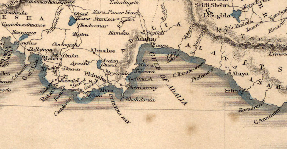
Abstract: This article describes the varied and inaccurate cartographic record made of part of the coastline of southwestern Anatolia from the 14th to the 19th century and the attempt to produce an accurate scientific sea chart of the Mediterranean in the 18th and 19th centuries. It describes the various later toponyms employed for the port city of Phaselis on this coastline, Ottoman Turkish and Greek, and suggests the toponyms Gironda-Phionda-Fironda-Fionda for the Orthodox See and for the port-city were all transcriptions of the Greek word Γέροντας (gerontas/gerondas) – Γέροντα (Geronta, later Greek, pronounced Yeronda) literally meaning elder, but also meaning Elder of the Greek Orthodox Church. Capt. Francis Beaufort’s influential account of rapid coastal erosion at Phaselis is investigated and it is suggested that man rather than nature, physical defacement rather than erosion, was responsible for the damage to the carved white marble sarcophagi in the North harbour. A reason is offered for the islands which were for centuries marked off this coastline as a maritime hazard, ‘Kephali tis Attalias’. This was probably in consequence of note being taken of the gasses and oil coming to the surface of the sea released in the course of eruptions from a series of underwater mud volcanoes forming the Anaximander Mountains, suggesting to mariners the presence of islands in the vicinity. Part of the 19th c. published record concerning the state of the inner harbour and harbour arm at Phaselis-Fionda is related in detail in the attempt to determine when and in what seismic event it was damaged, as in 1811 on Beaufort’s chart and in his text it is recorded of the harbour arm, “the masonry being still near perfect”. It is suggested that damage to the Phaselis inner harbour arm occurred between 1842 and 1904 when the inner harbour was described as ”fenced by a broken mole”and that this damage was caused by a local shallow depth seismic event not associated with a tsunami, perhaps in 1851, 1863, 1887 or 1897.
Keywords: Phaselis, Cartography, Toponyms, Γέροντας, Fionda, Geronda, Deface, Coastal-Erosion
Öz: Bu makale, 14. yüzyıldan 19. yüzyıla kadarki Güneybatı Anadolu sahil şeridinin bir kısmında yapılan çeşitli ve hatalı kartografik bir kaydı ve 18. ve 19. yüzyıllardaki doğru ve bilimsel bir Akdeniz deniz haritası üretim girişimini incelemektedir. Bu sahil şeridi üzerindeki Phaselis liman kentine verilen ve Osmanlı Türkçesi ile Hellence olan diğer toponymleri içermektedir. Ayrıca Ortodoks Piskoposluğu için Gironda-Phionda-Fironda-Fionda toponymleri ve liman kenti için Hellence, genel olarak yaşlı anlamına gelen ama aynı zamanda Yunan Ortodoks Kilisesi’nin kıdemlisi/mütevellisi anlamında da kullanılan Γέροντας (gerontas/gerondas) – Γέροντα (Geronta, geç dönem Hellencesi olup Yeronda şeklinde telaffuz edilmektedir) kelimesinin tüm transkripsiyonları öne sürülmektedir. Kaptan Francis Beaufort’un Phaselis’te meydana gelen ve hızla yayılan kıyı erozyonun etkileyici anlatımı incelenmiş; doğadan ziyade insanın, erozyondan ziyade de fiziksel tahrifin Kuzey Liman’daki beyaz mermerden oyulmuş olan sarkophagosun hasarından sorumlu olduğu ortaya konmuştur. Yüzyıllardır bu sahil şeridine komşu olan adalar için ‘Kephali tis Attalis’, denize ilişkin bir tehlike olarak sunulmaktadır. Muhtemelen, Anaksimandros Dağları’nı oluşturan bir dizi su altı çamur volkanından çıkan patlamalar sırasında açığa çıkan gaz ve deniz yüzeyine gelen petrole ilişkin alınan nota istinaden denizcilere çevredeki adaların varlığından bahsedilmekteydi. Phaselis-Fionda’daki iç liman ve liman kolunun durumuna ilişkin yayınlanan 19. yüzyıl kaydının bir kısmı, 1811 yılında Beaufort’un harita ve metninde “duvarcılık hala mükemmelliğe yakın” şeklinde yazıldığı gibi, ne zaman ve hangi sismik olayda hasar gördüğünün detaylı bir şekilde belirlenmesiyle bağlantılıdır. İç liman “kırık bir dalgakıranla çevrelenmiş” şekilde tasvir edilirken Phaselis iç liman koluna verilen hasarın 1842 ile 1904 yılları arasında gerçekleştiği ve söz konusu hasarın, belki de 1851, 1863, 1887 ya da 1897 yıllarında, bir tsunami ile ilişkili olmayan yerel sığ bir derinlikteki sismik olaydan kaynaklandığı öne sürülmektedir.
Anahtar Sözcükler: Phaselis, Kartografi, Toponym, Γέροντας, Fionda, Geronda, Tahrif, Kıyı Erozyonu
Antik Kaynaklar
Cons. Porph. de Them. (= Constantine Porphyrogeitus, de Thematibus): De thematibus. Studi e Testi, ed. A. Pertusi, Vatican 1952.
Strab. (= Strabon,Geographika): The Geography of Strabo. Trans.: H. L. Jones, volume V. 1928 (The Loeb Classical Library).
Steph. Byz. (= Stephanus Byzantius, Ethnika): Stephani Byzantii, Ethnikon: M. A. Westermann. Libsae 1839.
Modern Literatür
Alkan 2013 M. Alkan, “Toponym olarak “Symbolon” ve Lykia’daki iki Lagün”. Eds. N. E. Akyürek-Şahin, B. Takmer – F. Onur, Eski Çağ Yazıları 4. İstanbul (2013) 83-101.
Ambraseys 2009 N. Ambraseys, Earthquakes in the Mediterranean and Middle East – A Multidisciplinary Study of Seismicity up to 1900. Cambridge 2009.
Ambraseys – Finkel 1995 N. N. Ambraseys – C. F. Finkel, The Seismicity of Turkey and Adjacent Areas. A Historical Review 1500-1800. İstanbul 1995.
Anon. 1824 Anonymus, “The Modern Traveller, a Popular Description Geographical, Historical, and Topographical of the Varieus Countries of the Globe”. Syria and Asia Minor 2. London 1824.
Anon. 1829 Anonymus, London Encyclopaedia; or, Universal Dictionary of Science, Art, Literature and Practical Mechanics: Comprising a Popular View of the Present State of Knowledge. Volume IX. London 1829.
Anon. 1840 Anonymus, A Handbook for Travellers in the Ionian Islands, Greece, Turkey, Asia Minor and Constantinople, (no author given) John Murray. London 1840.
Anon. 1845 Anonymus, A Handbook for Travellers in the Ionian Islands, Greece, Turkey, Asia Minor and Constantinople, (no author given) John Murray. London 1845.
Anon. 1854 Anonymus, A Handbook for Travellers in Turkey: Describing Constantinople, European Turkey, Asia Minor, Armenia, and Mesopotamia. With New Travelling Maps and Plans. Third Edition, revised and greatly augmented, John Murray (Firm) London 1854.
Anon. 1878 Anonymus, Handbook for Travellers in Turkey in Asia: Including Constantinople, the Bosphorus, Plain of Troy, Isles of Cyprus, Rhodes, &c…, with General Hints for Travellers in Turkey, Vocabularies & c, J. Murray. London 1878.
Balducci 1987 H. Balducci, Rodos’ta Türk Mimarisi. Çev. C. Rodoslu. Ankara 1987.
Bean 1976 G. E. Bean, “Phaselis”, PECS The Princeton Encyclopedia of Classical Sites. Princeton 1976.
Beaufort 1817 F. Beaufort, Karamania: Or, A Brief Description of the South Coast of Asia-Minor and of the Remains of Antiquity. With Plans, Views, & Collected During a Survey of That Coast, Under the Orders of the Lords Commissioners of the Admiralty, in the Years 1811-1812. London 1817.
Beck 1822 C. D. Beck, Allgemeines Repertorium der Literatür für 1822, 3-4. Leipzig 1822.
Benndorf – Niemann 1884 O. Benndorf – G. Niemann, Reisen in Lykien und Karien. Wien 1884.
Benedict 1974 P. Benedict, Ula: An Anatolian Town, Brill 1974.
Biblia Pentapla 1712 Biblia Pentapla, d. i. die Bücher der heiligen Schrift nach fünffacher deutscher Verdolmetschung, Volume 3. Hollstein 1712.
Blackman et al. 2014 D. Blackman, B. Rankov, J. Pakkanen – K. Baika, Shipsheds of the Ancient Mediterranean. Cambridge 2014.
Blackman 197 D. J. Blackman, “The Harbours of Phaselis”. IJNA 2/2 (1973) 355-364.
Bohun 1653 E. Bohun, Mr. Bernard, A Geographical Dictionary, representing the present and ancient names of all the countries, provinces, remarkable cities, universities, ports, towns, mountains, seas, streights (sic), fountain, and rivers of the whole World, Their distances, Longitude and Latitude, With a short historical account of the same, and a general index of Ancient and Latin Names, London, Charles Brome, London, 1653.
Bohun 1693 E. Bohun, Mr. Bernard, A Geographical Dictionary, Representing the Present and Ancient Names of All the Countries, Provinces, Remarkable Cities, Universities, Ports, Towns, Mountains, Seas, Streights (sic), Fountain, and Rivers of the Whole World, Their Distances, Longitude and Latitude, With a Short Historical Account of the Same, and a General Index of Ancient and Latin Names. London 1693.
Brandon et al. 2014 C. J. Brandon, R. L. Hohlfelder, M. D. Jackson – J. P. Oleson, Building for Eternity: the History and Technology of Roman Concrete Engineering in the Sea. Oxford 2014.
Butler 1821 S. Butler, Geographia Classica: or, The Application of Ancient Geography to the Classics. New York 1821.
Cagnan – Tanircan 2009 Z. Cagnan – G. B. Tanircan, “Seismic Hazard Assessment for Cyprus”. Journal of Seismology 14/2 (May 2009) 225-246.
Cockerell 1903 C. R. Cockerell, Travels in Southern Europe and the Levant, 1810-1817. The Journal of C. R. Cockerell, R. A. Ed. S. P. Cockerell. New York and Bombay 1903.
Conder 1830 J. Conder, The Modern Traveller: A Description, Geographical, Historical, and Topographical, of the Various Countries of the Globe: Syria and Asia Minor. Volume 2, Boston 1830.
Cramer 1832 J. A. Cramer, A Geographical And Historical Description of Asia Minor with a Map. Oxford 1832.
Cuesta 1860 D. N. F. Cuesta, Ed. ‘Sir Carlos Fellows, Asia Menor’, Bibloteca Ilustrada De Gaspar Y Rois, Nuevo viajero universal,2 (Asia): enciclopedia de viajes modernos, recopilacion de las obras mas notables sobre descubrimientos, exploraciones y aventuras publicada por los mas celebres viajeros del siglo XIX, Humboltd, Bruckhardt, Livingstone, Parkyns, Huc, Clapperton, Leichhardt, etc. Madrid 1860, 593-615.
Çelikkol 1992 Z. Çelikkol, İstanköy’deki Türk Eserleri ve Tarihçe. Ankara 1990.
Dallaway 1797 J. Dallaway, Constantinople Ancient and Modern: With Excursions to the Shores and Islands of the Arcipelago and of the Troad. London 1797.
Dapper 1680 O. Dapper, Naukeurige beschryving van Asie: behelsende de gewesten van Mesopotamie, Babylonie, Assyrie, Anatolie, of Klein Asie: beneffens eene volkome beschrijving van gansch gelukkigh, woest, en petreesch of steenigh Arabie. Volume 1, Amtserdam 1680.
Dapper 1681 O. Dapper, Naukeurige beschryving van Asie: behelsende de gewesten van Mesopotamie, Babylonie, Assyrie, Anatolie, of Klein Asie: beneffens eene volkome beschrijving van gansch gelukkigh, woest, en petreesch of steenigh Arabie. Volume 1, Nürnberg 1681.
Darby 1846 Darby’s Universal Gazetteer: A Dictionary, Geographical, Historical, and Statistical, of the Various Kingdoms, States, Provinces, Cities, Towns, Forts, Harbors, Rivers, Lakes, Seas, Mountains, &c., in the World : Articles Relating to the United States Hav́e Been Very Largely Extended, Embracing Every County, with the Elements of Their Population Arranged in Tables from the Census of 1840, Philadelphia 1846
Denham 1973 H. M. Denham, Southern Turkey, The Levant and Cyprus: A Sea-Guide to the Coasts and Islands. London 1973.
Dipova – Cangir 2011 N. Dipova – B. Cangir, “Antalya İli Yerleşim Alanının Depremselliğinin Araştırılması”. Jeoloji Mühendisliği Dergisi 35/2 (2011) 93-114.
Duggan 2016 T. M. P. Duggan, “Patara’s Post-Antique Toponyms: Patera-Paterane-Pathera-Patera-Patere-Catara-Patora-Patosa-Panthera”. Eds. E. Dündar-S. Aktaş-M. Koçak-S. Erkoç, Havva İşkan’a Armağan, Lykıarkhıssa, festschrift für Havva İşkan. İstanbul 2016, 1-10.
Duggan – Aygün 2015 T. M. P. Duggan – Ç. A. Aygün, “The Medieval and Later Port of Myra/Stamira – Taşdibi”. Eds. S. Ladstätter, F. Pirson – T. Schmidts, Harbors and Harbor Cities in the Eastern Mediterranean from Antiquity to the Byzantine Period: Recent Discoveries and Current Approaches. Byzas 19/1 (2015) 245-269.
Echard 1786 L. Echard, Dictionnaire géographique-portatif, ou description des royaumes, provinces, villes, évêchés, duchés, comtés, marguirats, Paris, Les libraires associés. Paris 1786.
Erel-Adatepe 2007 T. L. Erel – F. Adatepe, “Traces of Historical earthquakes in the ancient city life at the Mediterranean region Tarihsel depremlerin Akdeniz Bölgesi antik kent yaşamındaki izleri”. Journal Black Sea/Mediterranean Environment, Vol. 13 (2007), 241-252 Source: dergipark.ulakbim.gov.tr/jbme/article/view/5000144470
Aslan – Baybo 2015 E. Aslan – S. Baybo, “2015 Phaselis Kent Limanları ve Sualtı Araştırmalarının Ön Değerlendirmesi”. Phaselis I (2015) 1-17.
Fellows 1839 C. Fellows, A Journal Written During an Excursion in Asia Minor 1838. London 1839.
Friendly 1977 A. Friendly, Beaufort of the Admiralty: the life of Sir Francis Beaufort, 1774-1857, London, 1977.
de Foris 1829 M. de Foris, Manuel de la géographie de Crozat, par demandes et par réponses ; seconde édition, augmentée du dictionnaire de toutes les villes de France… terminée par un tableau des moeurs, usages et coutumes des peuples des cinq parties du monde, par… J. H. Moronval. Paris 1829.
Foss 1994 C. Foss, “The Lycian Coast in the Byzantine Age”. Dumbarton Oaks Papers 48 (1994) 1-52.
Friderichs 1874 R. L. Friderichs, Theologisches Universal-Lexikon: zum Handgebrauche für Geistliche und gebildete Nichttheologen. Volume 2, Elberfeld 1874.
Goffman 2002 D. Goffman, “Jews in Early Ottoman Commerce, 15-34”. Ed. A. Levy, Jews, Turks, Ottomans: A Shared History Fiftheenth Through the Twentieth Century. New York 2002.
Görgün et al. 2016 E. Görgün, D. Kalafat – K. Kekovalı ,“Seismotectonics of the Antalya Basin and Surrounding Regions in Eastern Mediterranean from 8 to 28 December 2013 Mw 5.0–5.8 Earthquake Sequence”. Journal of Asian Earth Sciences (2016) 123-135.
Hamilton 1842 W. R. Hamilton, “Address”. Journal of the R.G.S., 12 (1842) xxxv-lxxxix.
Heikell 1985 R. Heikell, Turkish Waters Pilot: A Yachtsman’s Guide to the Aegean and Mediterranean Coasts of Turkey with the Island of Cyprus. London 1985.
Hellenkemper – Hild 2004 H. Hellenkemper – F. Hild, Lykien und Pamphylien I-II-III. (TIB 8). Wien 2004.
Hill 1983 J. Hill, “From Rome to Jerusalem: An Icelandic Itinerary of the Mid-Twelfth Century Author”, The Harvard Theological Review, Vol. 76, No. 2, 175-203, 1983. Source: http://www.jstor.org/stable/1509500
Hill 1952 G. Hill, A History of Cyprus. Volume IV. Cambridge 1952.
Hogarth 1910 D. G. Hogarth, Accidents of an Antiquary’s Life. London 1910.
Hugo 1842 V. Hugo, Le rhin: Tome 2. Paris 1842.
Kelletat – Schellmann 2002 D. Kelletat – G. Schellmann, “Tsunamis on Cyprus: Field Evidence and C14 Dating Results”. Z. Geomorph. N. F. 46 (Marz 2002) 19-34.
Kilburn – McGuire 2001 C. R. J. Kilburn – B. McGuire, Italian Volcanoes. Terra 2001.
Laughton 2004 J. K. Laughton, ‘Beaufort, Sir Francis (1774–1857)’, Oxford Dictionary of National Biography, rev. N. A. M. Rodger, 2004. http://dx.doi.org/10.1093/ref:odnb/1857.
Leake 1824 W. M. Leake, Journal of a Tour in Asia Minor, With Comparative Remarks on the Ancient and Modern Geography of That Country. London 1824.
Lexicon of Liddle and Scott H. G. Liddell, R. Scott, A Greek – English Lexicon. Oxford 1996.
Lippincott, 1895 Ed. Joseph Thomas, A Complete Pronouncing Gazetteer Or Geographical Dictionary of the World Containing Notices of Over One Hundred and Twenty-five Thousand Places. Philadelphia 1895.
Lloyd 1989 S. Lloyd, Ancient Turkey: A Traveller’s History of
Anatolia. Volume 1989/2. England 1989.
Luther 1596 M. Luther (Trans.), Biblia: Das ist: Die gantze heylige Schrift Teutsch. VT., Jesaia – Daniel. Th. 2, Strassburg 1596.
Luther 1831 M. Luther (Trans.), Haus-und Familienbibel; oder die ganze Heilige Schrift alten und neuen Testaments nach der deutschen Übersetzung D. Martin Luthers: ¬ Die heiligen Bücher des Alten Testaments, Volume 1, New York, 1831.
Lykousisa et al. 2009 V. Lykousisa, S. Alexandria, J. Woodside, G. de Langec, A. Dählmann, C. Perissoratis, K. Heeschenf, Chr. Ioakimd, D. Sakellarioua, P. Nomikoua, G. Rousakisa, D. Casase, D. Ballasa – G. Ercilla, “Mud Volcanoes and Gas Hydrates in the Anaximander Mountains (Eastern Mediterranean Sea)”. Marine and Petroleum Geology 26/6 (June 2009) 854-872. Source: http://www.sciencedirect.com/science/article/pii/S0264817208001013. Doi: http://dx.doi.org/10.1016/j.marpetgeo.2008.05.002
Makhairas 1932 Leontis Makhairas, Recital Concerning the Sweet Land of Cyprus Entitled “Chronicle”. Volume I, Trans. & Ed. R. M. Dawkins. Oxford 1932.
Merckel 1899 C. Merckel, Die Ingenieurtechnik im Alterthum. J. Springer 1899.
Moreri 1683 L. Moreri, Le grand dictionnaire historique, ou Le mélange curieux de l’histoire sacrée et profane. Tome 2/ 2. Paris 1683.
Newett 1907 M. M. Newett, Canon Pietro Casola’s Pilgrimage to Jerusalem in the Year 1494. Manchester 1907.
Newton – Pullan 1863 C. T. Newton – R. P. Pullan, A History of Discoveries at Halicarnassus, Cnidus & Branchidæ. Volume II. London 1863.
Norie 1831 J. W. Norie, New Piloting Directions for the Mediterranean Sea, the Adriatic, Or Gulf of Venice, the Black Sea, Grecian Archipelago: Containing Instructions for Navigating the Various Coasts, Islands, Bays, Ports, and Harbours, and for Avoiding the Numerous Rocks, Shoals, and Other Dangers in Those Seas. London 1831.
Norie 1841 J. W. Norie, New Piloting Directions for the Mediterranean Sea… London 1841.
Papadopoulos 2015 G. Papadopoulos, Tsunamis in the European-Mediterranean Region: From Historical Record to Risk Mitigation. Elsevier 2015.
Partington 1836 C. F. Partington, The British Cyclopædia of Literature, History, Geography, Law, and Politics. London 1836.
Penny 1839 The Penny Cyclopaedia of the Society for the Diffusion of Useful Knowldge, Massagetae – Muridae, 59-62, Volume XV. London 1839.
Pentreath 1990 Canon G. Pentreath, “Phaselis”. Ed. B. Cunliffe, Swans Hellenic Cruise Handbook 3: Turkey and the Black Sea. Oxford 1990.
Pîrî Reis 2013 Pîrî Reis, The Book of Bahriye T6605/Boyut 2013. Ed. B. Özükan, Kītab-ı Bahriye. İstanbul 2013.
Pîrî Reis 2002 Pîrî Reis, Kītab-ı Bahriye. Ed. B. Arı, Transcription from Osmalija to Turkish, A. Demir, English Translation, E. Özden, F. Özden, A. İlhan. Ankara 2002.
Pîrî Reis 1988 Piri Reis Kitab-ı Bahriye. Ed. E. Z. Ökte. İstanbul 1988.
Playfair 1881 R. L. Playfair, Handbook to the Mediterranean: Its Cities, Coasts, and Islands, for the Use of General Travellers and Yachtsmen. London 1881.
Purdy 1826 J. Purdy, The New Sailing Directory for the Mediterranean Sea, The Adriatic Sea, or, Gulf of Venice, The Archipelago and Levant, The Sea of Marmara and the Black Sea. London 1826.
Ramsay 2010 W. M. Ramsay, The Historical Geography of Asia Minor. Cambridge (1890) 2010.
Ravennatis 1860 Ravennatis Anonymi Cosmographia et Gvidonis Geographica, Ed. M. Pinder-E. Parthey in aedibvs Friderici Nicolai, Berolini 1860.
Sale et al. 1781 G. Sale, G. Psalmanazar, A. Bower, G. Shelvocke, J. Campbell, J. Swinton, An Universal History, from the Earliest Accounts to the Present Time. Volume 10. London 1781.
Salamon et al. 2007 A. Salamon, T. Rockwell, S. N. Ward, E. Guidoboni – A. Comastri, “Tsunami Hazard Evaluation of the Eastern Mediterranean: Historical Analysis and Selected Modelling”. Bulletin of the Seismological Society of America 97/3 (June 2007) 1–20.
Schaefer 1974 J. Schaefer, “Arbeiten in Phaselis: Ein zusammenfassender Bericht”. TAD XXI/2 (1974) 139-146.
Slade 1837 Sir. A. Slade, Turkey, Greece and Malta. Volume II, London 1837.
Smedley – Rose 1845 E. Smedley – H. J. Rose (Eds.), Encyclopædia Metropolitana; or, Universal Dictionary of Knowledge. Volume XXI. London 1845.
Smith 1863 Sir W. Smith, A Dictionary of the Bible. Volume II. London 1863.
Smith 1857 W. Smith (Ed.), Dictionary of Greek and Roman Geography: Iabadius-Zymethus. London 1857.
Smith 1872 W. Smith, W. Smith’s Dictionary of the Bible: Comprising Its Antiquities, Biography, Geography and Natural History. New York 1872.
Soysal 1981 H. Soysal, S. Sipahioğlu, D. Kolçak – Y. Altinok, Türkiye ve Çevresinin Tarihsel Deprem Kataloğu (M.Ö. 200-M.S. 1900). İstanbul 1981.
Sphyroeras et al. 1985 V. Sphyroeras, A. Avramea – S. Asdrahas, Maps and Map-Makers of the Aegean. Athens 1985.
Spratt – Forbes 1847 T. A. B. Spratt – E. Forbes, Travels in Lycia, Milyas, and the Cibyratis. Volume I. London 1847.
Texier 1862 C. Texier, Asie mineure description geographique, historique et archeologique des provinces et des villes de la Chersonnése d’Asie. Livre 1. Didot 1862.
Trigg 2016 S. Trigg “Optics and Geography in the Astronomical Commentaries of Fatḥallāh al-Shirwānī”. 361-383 in, Eds. A. C. S. Peacock-S. N. Yıldız, Islamic Literature and Intellectual Life in Fourteenth- and Fifteenth-Century Anatolia, Orient-Institut Istanbul, Bd. 34, Würzburg 2016.
Türkiye’nin Deprem Tehlikesi. T.C. Devlet Deprem Kataloğu. Ankara 1996.
Wahlen 1843 A. Wahlen, Nouveau dictionnaire de la conversation: ou répertoire universel … Volume 22. Bruselles 1843.
Wilski 1906 P. Wilski, Milet: Heft 1. Berlin 1906.
Worcester 1817 J. E. Worcester, A Geographical Dictionary, or Universal Gazetteer: Ancient and Modern in Two Volumes. Volume I. Andover 1817.
Yalçiner 2005 A. C. Yalçiner, U. Kuran, K. Minoura, F. Imamura, T. Takahashi, G. Papadopoulos – Ş. Ersoy, “Türkiye Kıyılarında Depreşim Dalgası (Tsunami) İzleri”. TMH – Türkiye Mühendislik Haberleri 438 (2005/4) 38-42.
Yerasimos 1991 S. Yerasimos, Les Voyageurs Dans L’Empire Ottoman (XIVe-XVIe) Bibliographie, Itinéraires et Inventaire des Lieux Habites. Ankara 1991.
Zach 1823 Baron du Zach, Correspondance astronomique, géographique, hydrographique et statistique du Baron du Zach, Genés 1823.
Web Kaynakları
https://upload.wikimedia.org/wikipedia/commons/9/94/Map_of_Angelino_Dulcert_cropped.jpg
https://www.raremaps.com/gallery/enlarge/35822
http://www.ebay.ca/itm/Geographiae-Sacre-Mediterranean-Old-map-Sanson-1668-/282121790951?hash=item41afc4e5e7:g:uboAAOSwA3tXocxf
http://www.mapandmaps.com/24476-thickbox_default/middle-east-hebrew-track-original-old-map-chart-sanson-mercator-1683-1734.jpg
http://www.mapandmaps.com/en/middle-east-antique-old-maps/2181-middle-east-hebrew-track-original-old-map-chart-sanson-mercator-1683-1734.html
https://upload.wikimedia.org/wikipedia/commons/0/0e/Moll,_Herman._Turkey_in_Asia%3B_or_Asia_Minor_%26c._1736.jpg
http://www.davidrumsey.com/luna/servlet/detail/RUMSEY~8~1~233573~5509714:Composite–A-Map-of-the-Environs-of
https://commons.wikimedia.org/wiki/File:1741_Homann_Heirs_Map_of_Ancient_Greece_%5E_the_Eastern_Mediterranean_-_Geographicus_-_Graecia-homannheirs-1741.jpg.
http://www.biographi.ca/en/bio/chabert_de_cogolin_joseph_bernard_de_5E.html
http://gallica.bnf.fr/ark:/12148/btv1b5962163s/f1.highres
https://upload.wikimedia.org/wikipedia/commons/4/4c/Anville%2C_Jean_Baptiste_Bourguignon._Turkey_in_Asia._1794_%28A%29.jpg;
http://www.davidrumsey.com/luna/servlet/detail/RUMSEY~8~1~24847~970001:Turkey-in-Asia-#
https://upload.wikimedia.org/wikipedia/commons/1/1e/1794_Anville_Map_of_Asia_Minor_in_Antiquity_(Turkey,Cyprus,_Syria)_-_Geographicus_-_AsiaMinor-anville-1794.jpg
https://upload.wikimedia.org/wikipedia/commons/4/4c/Anville%2C_Jean_Baptiste_Bourguignon._Turkey_in_Asia._1794_%28A%29.jp
http://www.davidrumsey.com/luna/servlet/detail/RUMSEY~8~1~24847~970001:Turkey-in-Asia-
http://digi.ub.uni-heidelberg.de/diglit/beaufort1817/0016?sid=13ebd55774f4cca05a8477a404feb33b
https://commons.wikimedia.org/wiki/File:William_Faden._European_Dominions_of_the_Ottomans_or_Turkey_in_Europe._1795.jpg
http://discovery.nationalarchives.gov.uk/details/r/C16280
https://www.raremaps.com/gallery/enlarge/48160
http://studybible.info/compare/1%20Maccabees%2015:23
https://www.raremaps.com/gallery/detail/33883dc/Carte_Nouvelle_De_La_Mer_Mediterranee_ou_sont_Exactement_Remarques_tous_les/De%20Hooghe.html;
https://www.raremaps.com/gallery/enlarge/33883dc
http://cyprussite.com/img/map05.jpg
http://cyprussite.com/img/map24.jpg
http://gallica.bnf.fr/ark:/12148/btv1b5962140s/f1.item.zoom Carte_de_la_Grèce_dressée_[…]Delisle_Guillaume_btv1b5962140s
http://eng.travelogues.gr/item.php?view=54434
http://tile.loc.gov/image-services/iiif/service:gmd:gmd7:g7420:g7420:ct003757/full/pct:12.5/0/default.jpg
https://www.loc.gov/item/2004629155/http://eng.travelogues.gr/item.php?view=60228
http://www.haritatr.com/harita/Yeronda-Bay/11667
http://collections.rmg.co.uk/collections/objects/539782.html
http://en.wikipedia.org File: Portolan_chart_of_Gariel_de_Vallseca_(1447).jpg
http://eng.travelogues.gr/item.php?view=60228
http://gallica.bnf.fr/ark:/12148/btv1b5962140s/f1.item.zoom Carte_de_la_Grèce_dressée_[…]Delisle_Guillaume_btv1b5962140s
http://eng.travelogues.gr/item.php?view=54434
http://tile.loc.gov/image-services/iiif/service:gmd:gmd7:g7420:g7420:ct003757/full/pct:12.5/0/default.jpg
https://www.loc.gov/item/2004629155/
http://art-of-maps.blogspot.com.tr/2011_10_01_archive.html
http://gallica.bnf.fr/ark:/12148/btv1b5962140s/f1.highres
http://tr.travelogues.gr/item.php?view=54248
http://maps.turkishpostalhistory.com/index.php/harita/1720-Weigel-Turkey
http://www.columbia.edu/itc/mealac/pritchett/00maplinks/mughal/devaugondy/atlas1749/turkeyasia1749.jpg
https://commons.wikimedia.org/wiki/File:1780_Raynal_and_Bonne_Map_of_Turkey_in_Europe_and_Asia_-_Geographicus_-_TurquieEurope-bonne-1780.jpg
http://thumbs4.picclick.com/d/w1600/pict/282116922895_/1794-Turkey-In-Asia-Middle-East-By-Wilkinson.jpg
https://upload.wikimedia.org/wikipedia/commons/thum/a/ac/William_Faden._European_Dominions_of_the_Ottomans_or_ Turkey_in_Europe._1795.jpg/2048px-William_Faden._European_Dominions_of_the_Ottomans_or_Turkey_in_Europe._1795.jpg
https://upload.wikimedia.org/wikipedia/commons/f/fd/1801_Cary_Map_of_Turkey,_Iraq,_Armenia_and_Sryia_-_Geographicus_-_TurkeyAsia-cary-1801.jpg
http://ids.lib.harvard.edu/ids/view/22397657?buttons=y;
http://aligunduz.org/img/maps/OttomanAsia.jpg
http://www.perseus.tufts.edu/hopper/text?doc=Perseus%3Atext%3A1999.01.0239%3Abook%3D14%3Achapter%3D3%3Asection%3D9
http://www.mapsofantiquity.com/store/Heather_Chart_of_the_Mediterranean_Sea/inventory.pl?id=NAU130
http://www.geographicus.com/P/AntiqueMap/MediterraneanSeaEast-heather-1822
http://discovery.nationalarchives.gov.uk/details/r/C16280
http://www.nationalarchives.gov.uk/help-with-your-research/research-guides/admiralty-charts-maps/
http://www.ebay.com/itm/1822-William-Heather-and-John-Norie-Nautical-Chart-of-the-Eastern-Mediterranean-/361655726923#cvip_desc
https://www.raremaps.com/gallery/enlarge/35686dc
https://www.raremaps.com/gallery/enlarge/35822
http://www.mapsofantiquity.com/store/A_correct_Chart_of_the_Mediterranean_Sea,_from_the_Straits_of_Gibraltar_to_the_Levant,_From_the_latest_and_best_Observations:_for_Mr._Tindal’s_Continuation_of_Mr._Rapin’s_History.*****SOLD*****/inventory.pl?id=EUR248JR
https://upload.wikimedia.org/wikipedia/commons/2/2e/1818_Pinkerton_Map_of_Turkey_in_Asia,_Iraq,_Syria,_and_Palestine_-_Geographicus_-_TurkeyAsia-pinkerton-1818.jpg
https://www.raremaps.com/gallery/detail/34696mb/A_New_Chart_of_the_Mediterranean_Sea_Comprehending_the_Coasts_from_Cape_St/Smyth-Laurie.html
https://www.raremaps.com/gallery/enlarge/34696mb
http://www.atlassen.info/kaarten/algemeen/sduk/picslarge/sduk001k083.jpg
http://dl.mospace.umsystem.edu/mu/islandora/object/mu%3A110887
https://upload.wikimedia.org/wikipedia/commons/6/69/Martin,_R.M.%3B_Tallis,_J._%26_F._Turkey_in_Asia._1851_(H).jpg
http://dl.mospace.umsystem.edu/mu/islandora/object/mu%3A357253
http://www.britishmuseum.org/research/collection_online/collection_object_details.aspx?objectId=3468808&partId=1&searchText=Charles+Robert+Cockerell&page=4
http://www.britishmuseum.org/research/collection_online/collection_object_details/collection_image_gallery.aspx?assetId=1127922001&objectId=3439635&partId=1
http://www.britishmuseum.org/research/collection_online/collection_object_details/collection_image_gallery.aspx?assetId=1127919001&objectId=3439638&partId=1
http://www.britishmuseum.org/research/collection_online/collection_object_details/collection_image_gallery.aspx?assetId=1128449001&objectId=3440015&partId=1
http://www.perseus.tufts.edu/hopper/text?doc=Perseus%3Atext%3A1999.04.0006%3Aentry%3Dphaselis
http://collections.rmg.co.uk/collections/objects/539785.html
https://en.wikipedia.org/wiki/Phaselis
http://www.antalyafourseasons.com/privatedetay.asp?kategori_no=11
www.turkishyachtchartering.com/phaselis.html
https://www.lonelyplanet.com/turkey/phaselis
http://collections.rmg.co.uk/collections/objects/539785.html
http://www.britishmuseum.org/research/collection_online/collection_object_details/collection_image_gallery.aspx?assetId=1128017001&objectId=3439673&partId=1
http://earthquake.usgs.gov/earthquakes/eventpage/usb000s99n;
http://earthquake.usgs.gov/earthquakes/eventpage/us20003jvl#executive
http://web.itu.edu.tr/~taymaz/docs/2007-Yolsal-etal-SP291Understanding%20Tsunamis%20in%20the%20 Eastern%20Mediterranean-2007.pdf
http://www.deprem.gov.tr/en/historicalevent 1851
http://www.deprem.gov.tr/en/historicalevent 1856
http://www.deprem.gov.tr/en/historicalevent 1858, B3 37.0000 31.0000 Antalya, magnitude V
http://www.deprem.gov.tr/en/historicalevent
http://www.deprem.gov.tr/en/historicalevent ; 1864
http://www.deprem.gov.tr/en/historicalevent ; 1887
https://en.wikipedia.org/wiki/List_of_earthquakes_in_1911
http://earthquake.usgs.gov/earthquakes/eqarchives/year/1999/1999_08_17_eq_list.php
http://earthquake.usgs.gov/earthquakes/eventpage/i
Resim Kaynakları
1. https://upload.wikimedia.org/wikipedia/commons/9/94/Map_of_Angelino_Dulcert_cropped.jpg
2. http://www.ebay.ca/itm/Geographiae-Sacre-Mediterranean-Old-map-Sanson-1668 /282121790951?hash=item41afc4e5e7:g:uboAAOSwA3tXocxf
3. https://commons.wikimedia.org/wiki/File:1741_Homann_Heirs_Map_of_Ancient_Greece_%5E_the_Eastern_Mediterranean_-_Geographicus_-_Graecia-homannheirs-1741.jpg
4. Engraving of Jean-Baptiste Hilaire’s View of the Public Square of Cos of 1776, Author’ collection
5. http://gallica.bnf.fr/ark:/12148/btv1b5962163s/f1.highres
6.https://upload.wikimedia.org/wikipedia/commons/1/1e/1794_Anville_Map_of_Asia_Minor_in_Antiquity_(Turkey,Cyprus,_Syria)_-_Geographicus_-_AsiaMinor-anville-1794.jpg
6a. detail
6b.https://upload.wikimedia.org/wikipedia/commons/4/4c/Anville%2C_Jean_Baptiste_Bourguignon._Turkey_in_Asia._1794_%28A%29.jpg
7.https://commons.wikimedia.org/wiki/File:William_Faden._European_Dominions_of_the_Ottomans_or_Turkey_in_Europe._1795.jpg
8. Photograph F. Yilmaz
9. https://www.raremaps.com/gallery/enlarge/33883dc
10. http://gallica.bnf.fr/ark:/12148/btv1b5962140s/f1.highres
11. http://tr.travelogues.gr/item.php?view=54248
12. http://maps.turkishpostalhistory.com/index.php/harita/1720-Weigel-Turkey
13.http://www.columbia.edu/itc/mealac/pritchett/00maplinks/mughal/devaugondy/atlas1749/turkeyasia1749.jpg
14.https://commons.wikimedia.org/wiki/File:1780_Raynal_and_Bonne_Map_of_Turkey_in_Europe_and_Asia_-_Geographicus_-_TurquieEurope-bonne-1780.jpg
15. http://thumbs4.picclick.com/d/w1600/pict/282116922895_/1794-Turkey-In-Asia-Middle-East-By-Wilkinson.jpg
16. https://upload.wikimedia.org/wikipedia/commons/thumb/a/ac/William_Faden._European_Dominions_of_the_Ottomans_or_Turkey_in_Europe._1795.jpg/2048px-William_Faden._European_Dominions_of_the_Ottomans_or_Turkey_in_Europe._1795.jpg
17.https://upload.wikimedia.org/wikipedia/commons/f/fd/1801_Cary_Map_of_Turkey,_Iraq,_Armenia_and_Sryia_-_Geographicus_-_TurkeyAsia-cary-1801.jpg
18.https://upload.wikimedia.org/wikipedia/commons/2/2e/1818_Pinkerton_Map_of_Turkey_in_Asia,_Iraq,_Syria,_and_Palestine_-_Geographicus_-_TurkeyAsia-pinkerton-1818.jpg
19. https://www.raremaps.com/gallery/enlarge/34696mb
20. http://www.atlassen.info/kaarten/algemeen/sduk/picslarge/sduk001k083.jpg
21. http://dl.mospace.umsystem.edu/mu/islandora/object/mu%3A110887
22. https://upload.wikimedia.org/wikipedia/commons/6/69/Martin,_R.M.%3B_Tallis,_J._%26_F._Turkey_in_Asia._1851_(H).jpg
23. http://dl.mospace.umsystem.edu/mu/islandora/object/mu%3A357253
24. Beaufort, Karamania: Or, A Brief Description of the South Coast of Asia-Minor, 1817, 56.
25. http://www.britishmuseum.org/research/collection_online/collection_object_details/collection_image_gallery.aspx?assetId=1128017001&objectId=3439673&partId=1
26. http://www.britishmuseum.org/research/collection_online/collection_object_details/collection_image_gallery.aspx?assetId=1128017001&objectId=3439673&partId=1
27. Oil painting of the inner harbour arm at Phaselis, August 2013-August 2014, T. M. P. Duggan.
T. M. P. Duggan, “Depicting and Charting the Southern Coastline of Anatolia – Record of the Later Toponyms of Phaselis: Palyopoli-Paleopolis, Tekiroba, Gironda-Phionda-Fironda-Fionda – The 1812 Report of Rapid Coastal Erosion – The (Doubtful?) Islands and Evidence leading Towards a Date for the Collapse of the Upper Courses of the Inner Harbour Arm at Ancient Phaselis, Antalya”. Phaselis III (2017) 1-49. DOI: 10.18367/Pha.17001
Kalıcı bağlantı adresi: http://dx.doi.org/10.18367/pha.17001
T. Mikail P. Duggan
Öğr. Gör., Akdeniz University, Mediterranean Civilisations Research Institute, Antalya. tmpduggan@yahoo.com